THE CAVES OF HABIKAH
© 2005 by John and Susy Pint Updated November, 2017
In March and April of 2001, we found and explored an important new karst area that will keep Saudi cave explorers busy for years.
We owe it all to Mr. Faisal Al-Zamil of AlKhobar who was turned on to desert caving by the Saudicaves.com website and who then steered us by email towards Habikah Village, often spelled Habakah or Habkah, but pronounced "ha-BI-kah by the local people.
After flying to tiny Rafha, we took the TransArabian Pipeline (TAPline) road west and looked for a sign for Habakah. We saw the sign, turned off the road and soon found ourselves confronted by a plethora of rough tracks leading every which way. Only because we had put the approximate location of the village in our GPS's were we able to correctly pick the most likely track most of the time.
BIG DHUBB CITY
Along the way, we came across dozens of enormous dhubbs (spiny-tailed lizards) which would rush toward their dhubb-holes as soon as we approached them, somehow managing to combine a dash with a waddle in a most unique manner.
In due time, the desert began to look greener and greener and we started to see outcrops of "prickly rock" indicating good karst for caves. A Sudanese shepherd told us we were now two kms from Habikah while the GPS showed 22 to go. Well, maybe the shepherd needs an odometer on his staff because the GPS turned out right. By the way, the shepherds around here all have several husky dogs "because," they told us, "the wolves around here are big and plentiful." Later we found out just where these wolves live.
At last we came to the village, located right alongside... a small lake! Yes, a spring-fed pool in the desert, next to which people have dug over 70 holes to pump up water into the big tankers that bedouins in remote places now depend on. Apparently 200 such holes in this area draw on the same water source. We drove into the village and spotted a boy in front of a very small store. His name was Sa'ad and he turned out to be a prince, the son of the Emir and very much into ...yes, cave exploring! He was delighted at the prospect of us accompanying him into the nearest cave, which was in a hill visible from the village, because "No one but my little brother is willing to go in there with me."
We agreed to go to the cave the next day. Before we left, Sa'ad asked why we had taken such a long route to get to Habikah. "You could have taken the big road... it leads straight to the TAPline." Indeed, we discovered that this wide, graded road was straight as an arrow and intersects the TAPline at a spot many kms west of where the perfidious "Habakah" sign is located. Naturally, there is no sign of any sort indicating the good road.
The sun was setting, so off we went towards the cave to find a campsite. A spot we did find, but when we stepped out of the trucks we were overwhelmed by a huge black cloud of the world's largest mosquitoes! In some areas mosquitoes carry dengue fever or malaria, so we tried three more locations near the spring and then decided to head north five kms on the famous graded road. Here there wasn't much to look at, but no monster mosquitoes either. After a delicious kabsa dinner, we all flopped into our tents utterly exhausted.
WHATAGOODNAME CAVE
We awoke to clanking bells on bellowing sheep. At Habikah village the Emir told us his son had gone off to find us. We then drove to cave which had an unimposing, low horizontal entrance covered with graffiti. Inside, however, we found stalactites, bat guano and two main passages with lots of darkness beyond. We also found a complete fox body which had been totally flattened and mummified and looked like it had come out of a Roadrunner cartoon.Then Sa'ad and little brother appeared. "Is this Serdab Cave?" we asked. "There are many serdabs," they replied, "and this is one of them." It soon became clear that the word serdab refers to any horizontal cave, so we asked for the name of THIS particular one.
"Er, you can call it "Serdab Tayib Al Issim" replied Sa'ad with a smile. Well, "Tayib Al Issim" means, "nice name" and for many years bedouin were able to pass this off to explorers and surveyors who insisted on a name when there wasn't one.
INTO THE WOLVES' DEN
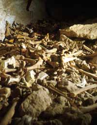
We followed the two brothers, who were clad in sandals and thobes, into a right-hand branch of the left-hand passage and immediately realized this was a biggie. Moving quickly through spacious galleries, we came upon many caches of animal bones and lots of wolf scat, some old and dried and some uncomfortably recent. The boys insisted that wolves live in all the local caves and now this looked like a lot more than a myth. Once we realized we were going deep into a large and complex cave, we got out the flagging tape and started marking our return route, just in case our guides ended up eaten by the wolves.
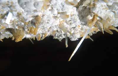
There were lots of stalactites in the cave and we found a few very fat stalagmites which had been broken open and hollowed out, the inside consisting of soft gypsum. There were also gypsum flowers, needles and strings. The heaps of bones continued wherever we went, but deep inside the cave we found thousands of dried up "hyena poops" very much like Murubbeh's. They looked just as old, too (Murubbeh's are a thousand years old).
 Old
bat guano (from insect-eating bats) we encountered
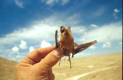
everywhere, but I wondered where the bats had gone. At last, we did
find one
live bat which had squeezed into a small hole in the wall and peeked at
us from
inside. This seemed most peculiar behavior for a bat, but then we
noticed that
several black and orange stains we had seen on the walls had a small,
bat-sized
hole above them. The black stain looked very much like vampire guano to
me (from
Desmodus rotundus) and we wondered just what these particular bats had
been
eating. Fortunately, we found a well-preserved, mummified bat which
should make
identification easy. It looks like this cave had large colonies of
insect-eaters
in the past but now harbors a small number of some species of "loner"
which lives in small holes.
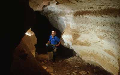
Next, we drove off to "the smaller cave" south of the village. To our amazement, it had a huge, awe-inspiring entrance, the most picturesque we have ever seen in this country, leading into an enormous room. Just the sight of people walking down a dusty trail into the cave, backlit by a beam of sunlight was impressive. But I’ll get back to this cave, now called Black Scorpion Cave, farther down the page.
DAHL RAJUL MAKSURA: THE BROKEN-LEG-MAN DAHL
The next cave we visited had been categorized as "not very important" only because the boys couldn't get inside. This one turned out to be a dahl or vertical pit about 7 meters across. Lying on the floor, about seven meters below the entrance, we could see three bedsprings wired together. It seems a local guy had tried to use these as a ladder and had ended up on the bottom with a broken leg. To the boys' knowledge, this cave was still unexplored.
Sa'ad joined us for the descent by cable ladder, wearing a harness over his rolled-up thobe. The second man down spotted a big black scorpion right below him, next to the remains of the bedspring "ladder". We dispatched the scorpion and looked around us. We were in a wide room about 50 meters across, standing on top of a huge heap of breakdown. We made our way down one steep slope until we were about 16 meters below the surface. Here a collective WOW! resounded from all of us. The ceiling above us was covered with a dense set of impressive formations of all sorts: banded draperies, soda straws, stalactites, helictites, etc. We found extensive displays like this in three places and could hardly believe our eyes, especially because underfoot there was nothing but dusty breakdown covered with dove guano. Here we found two baby doves in nests on the floor, showing us how secure those birds felt in this cave.
SA'AD'S UNDERGROUND LAKE
One more interesting cave in the area is said to house an underground lake. Here we found a low passage that was unusually COLD and heading downward, but we had to leave it for the future.
THE AR AR CONNECTION
Next day we drove to Rafha, only to find we had again missed our flight, even though, according to us, we were four hours early. The only option left to us was to drive to a town called Ar Ar, 300 kms away and fly the next morning. A few kms later, we drove into a howling sandstorm that lasted all the way to Ar Ar. After a noisy night in a 70-riyal hotel, we headed for the airport, where our baggage was minutely inspected by a soldier with whom we later struck up a conversation about dahls. It turned out he was a natural caver who knew the caves we had visited and who had located some equally big ones NW of Habikah. He promised us the GSP coordinates, so our detour to Ar Ar was not at all in vain and our eyes are now turned "beyond Habikah."
CLICK HERE FOR 12-SECOND "SANDSTORM" VIDEO
RETURN TO HABIKAH
On April first, 2001, seven SGS cavers and three drivers set out from Ar Ar and set up camp near the biggest cave, to begin our surveying and photographing projects.
After setting up camp, we were treated to the sight of hundreds of bats silently zooming out of the cave entrance. Then, at 1:00 AM that night, we were joined by Khalid Otaibi, the airport guard we had met on our last visit.
Next day we divided into two teams. One went off with Mahmoud and Khalid to get the GPS coordinates of caves farther west while the second team began to survey Black Scorpion Cave with John.
DISTO MAPPING
We mappers were able to move along at a good speed thanks to a digital measuring device called a "Disto." This projects a laser beam at a wall up to 100 meters away and gives quite an accurate reading of the distance, even if the wall is extremely rough. After testing this gizmo against a measuring tape (with satisfying results) we used rubber bands to attach it to our SmartLevel digital clinometer and found we could get readings up, down, left and right of every station in a few seconds. No doubt the Disto will be responsible for adding unwanted pounds to the waistlines of future cavers. On this day we mapped 16 stations, back to the area with large gypsum flowers.
THE WIND TUNNEL OF MUNBATAH
Just after nightfall, the Away Team returned with major news: after five hours of back-breaking bouncing over no roads at all, they arrived in the right area but found that the coordinates which Khalid had received from a friend were inaccurate, in fact, 500 meters off target. But when they finally stepped into an enclosed depression known as "Munbatah," they realized that their long, hard drive had not been in vain, for a powerful and icy wind was roaring out of a 70-cm hole on the side of the depression. "It's just like air conditioning," a local bedu told them, "and we come here to sit when the weather is hot."
Mahmoud Alshanti described the wind velocity as "fierce -- so strong you can barely move forward into the hole." He says it is big enough to crawl through, but cavers will may want to use goggles and a ski mask for protection against flying pebbles and dust loosened by someone crawling up ahead. The local people say this hole blows just as strongly day and night, all year round and that to their knowledge no one has ever gone inside.
CLICK HERE FOR 30-SECOND "NATURAL A.C." VIDEO
INTO THE BELLY OF THE BLACK SCORPION
The next morning, we awoke to fiercely flapping tents. After breakfast, we set up two teams, one to continue the survey of the cave and the other to do photography.
 We
photographers filed through the spacious entrance room
to the small opening at the back left where you would hardly guess
there is a passage. A bit of stooping is required to pass from this
point into
the Majlis Al Thiabeh which is 100 meters long and 17 meters high. This
room is
filled with several great heaps of rock, making it impossible to see
the other
wall most of the time (20 to 30 meters away). On the floor are several
caches
containing many hundreds of bones of all sizes. These deposits are much
bigger than
any we have found on the Summan Plateau. There is both hyena and wolf
scat here
and many of the bones look like they are not more than a few years old.
You can find your way through this room very easily, by always hugging the right wall. The cave heads almost perfectly south to a point where the ceiling drops to 3 meters high and the passage forks. The left fork is the Gorfat al Macarona, named for the many noodle-like gypsum formations lining the ceiling, walls and shelves. The right passage requires some crawling and goes for some 130 meters back to a final room, the Majles al Khofafish where a large colony of insect-eating bats lives. These bats were observed on two evenings to leave the cave at dusk, providing a spectacular show, but our attempts to photograph them properly failed. The fact that they exit the main entrance suggests this cave may have no other entrances. Stuffiness in this back room suggests the same. This area has both fresh and very old guano deposits. The old guano is extremely dry and the piles are "eroded," displaying strata related to past deposits. This guano should be carbon dated, as it could be older than we imagine.
DANCING NOODLES
| ... Next comes a narrow passage my companions
decided to name The Gorfat al
Macarona or Spaghetti Room. It has an amazing variety of small gypsum
formations...
|
 |
| ... If an ant were
walking on these walls, it would be weaving through a dizzying
landscape,
sometimes crisscrossed with long gypsum swords set at various angles...
|
 |
My plan was to photograph "small stuff" first and then do passages and people. However, each time I tried to stop the macro photography, Abdulrahman would point to some new shelf that we couldn’t possibly skip. Even a small hole in the low ceiling would turn out to contain an amazing scene, once we’d shone a bright flashlight into it. Of course, each picture required a long time to take and while I was shooting the tiny formations in a hole we called The Belly Button, Rami came to me and asked, "What’s that noise?" Once we were all quiet, we could distinctly perceive the rise and fall of a distant buzzing...
For the pictures of the Macarona passage itself, we used our two Coleman lanterns to light the place up with a warm glow (thanks to the good example set by Lars Bjurstrom) and then combined flash with lanterns. At this point our drivers began to arrive to see just what had captured our attention, so I got a few pictures of them. Several looked quite quaint, and you can scroll down to the bottom of this report to see what I mean.
Now the survey team returned from the bat zone, all of them in a big hurry to get out of the cave. "We surveyed 17 more stations right to the end of the cave," said Mahmoud. "You should have seen all the bats! But we were breathing clouds of dust and we’ve got to get outside for some fresh air." The total of all our station to station measurements was 471.43 meters.
Most of my team was ready to leave too, but Rami and I stayed for a few last shots before joining the others, who had not exited the cave after all, because the drivers had set up camp inside the big entrance room, which was cool and comfortable while outside it was hot and blowing like mad. To me, it was most interesting to see the transition from avoidance of the cave, complaints about its smell, fear of wolves, etc. to spontaneously choosing the entrance for a meal and even proposing to camp and sleep in this big room once the weather really gets hot. At their own pace, the Saudis are becoming cavers, even the drivers!
UNLUCKY DOVES
After eating, we did Khalid the only favor he had asked of us: a visit to Dahl Rajul Maksura where he hoped to bag some pigeons to feed some falcons he is training. We stepped outside and found three of our tents blown down and the wind stronger than ever. Though some of us had headaches from the heat, wind and strain, we willingly piled into two vehicles and lowered our cable ladder and rope into the dahl, this time taking measurements. Only Khalid, Ahmed and I went down inside.
I checked the opposite side of this room from the where the fabulous stalactites are located and found there are rather large rooms very far down below, with lots of doves living there. A complete circuit of the room really needs to be made, but will be dangerous because the breakdown is very unstable and even the cave roof has areas that look ready to collapse. While I looked around, Khalid the hunter bagged six doves which he will use for training his falcons.
Next we broke camp and headed for the TAPline at breakneck speed, which doesn’t have to be too fast when the graded road you are driving on is rougher than the bedu tracks all around you. Still, it took until 9:30 PM to make Ar Ar, where we hit the sack in a new hotel, where Mahmoud talked the night clerk into giving us huge discounts. Everyone was dead tired.
BONZAI PALM TREES
Next morning, after shakshuga (scrambled eggs with tomato and onion) at our favorite restaurant, we went to the airport where our friend Kahlid sped us through the multiple inspections. Then we sat down for tea and struck up a conversation with a man who knows about a big dahl over 30 meters around. . "The hole is very deep, so deep that a truck tire at the bottom looks the size of a wedding ring," he told us. It was about the size of one of these tungsten rings. And on top of that, he claims it’s filled with palm trees which look like bonzais at such a distance....John Pint