|
By John Pint
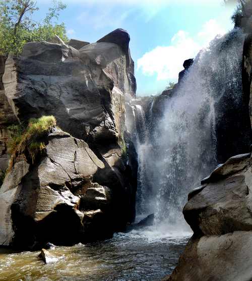 Los Chorros are the only “serious” waterfalls along the entire length
of the river known both as Rio Caliente (Hot River) and—after it cools
down—Rio Salado (Salty River). They are located 23 kilometers west of
Guadalajara and reachable via highway 70, the route to Tala and Ameca.
Los Chorros are the only “serious” waterfalls along the entire length
of the river known both as Rio Caliente (Hot River) and—after it cools
down—Rio Salado (Salty River). They are located 23 kilometers west of
Guadalajara and reachable via highway 70, the route to Tala and Ameca.
These beautiful falls are described in the 2011 edition of Outdoors in
Western Mexico, Volume 1. Figuring it was time for an update, I visited
the place recently to see what’s new. The first thing I should mention
is that there is now a concrete divider running down the center of most
of highway 70, meaning that people coming from Guadalajara can no
longer make a simple left turn to get to Los Chorros. No, you now have
to drive an extra three kilometers to the first place you can make a
U-turn and then another three kilometers back to the Chorros Road.
“The fact that people can’t make that left turn has killed our
business,” I was told by Hector Cuevas, one of the owners of Los
Chorros. And, as a result, he told me that the main emphasis of Los
Chorros has shifted from picnickers and bathers to wedding parties,
where the bride and groom can tie the knot outdoors with the majestic
falls providing the perfect backdrop for envy-of-the-barrio wedding
photos.
In my book, all of this is good news. It means there is now far less
noise and there are far fewer people at Los Chorros on a
weekend. So, on the work day of your choice, you’re
practically guaranteed to have the entire place to yourself. 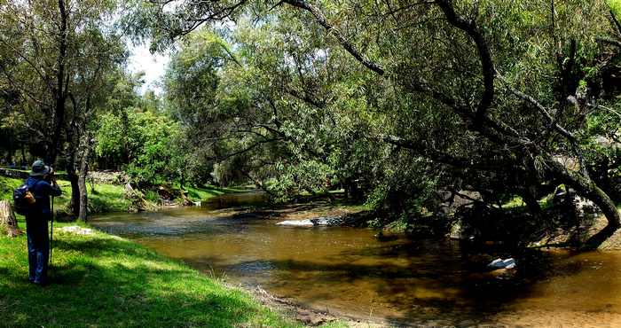
Peaceful and Picturesque, el Río Salado makes its way
from Los Chorros to Presa la Vega where it emerges as the Río Ameca,
which flows all the way to Puerto Vallarta.
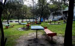
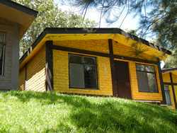
Another plus is that all the cabins are being renovated. We took a look
at one where an ample Jacuzzi is being installed, from which you’ll be
able to watch a giant plasma TV while enjoying your hot, bubbly bath.
The cabins are set back in a charming wooded area, well away from the
picnickers. They now cost 1200 pesos per night and are designed for
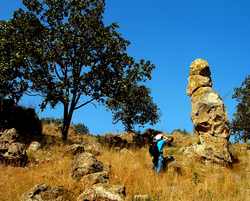
four people. To my surprise, I discovered there are some extraordinary
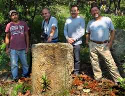
rock formations close to these cabins. The Tala area is famous for its
Fossil Fumaroles, which stick up out of the ground like small tree
stumps… so small that we used to call them Fairy Footstools. However,
these Stone Stumps at Los Chorros are each over a meter tall, just
about the right height to serve as a stone-age lectern for an outdoor
talk on the geology of the Primavera Forest.
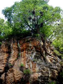
There are two trails by which you can get up to the top of the
waterfalls, which, I think, are even more spectacular when viewed from
above than from the bottom. However, I was told that the paths leading
up there are so overgrown with vegetation during the rainy season that
you need a machete to get through. Fortunately, thanks to Jim Boles and
his hardy lakeside hikers, I learned about another route leading to the
head of these falls, which lie in a most interesting area called El
Tempisque. Stand by for an article on this site, coming soon.
Back to Los Chorros: “Swimming” at the base of these waterfalls has
been reduced to splashing in the shallow river, as people are no longer
allowed near the base of the falls, where more than one unlucky visitor
has drowned in the past, trapped in a kind of whirlpool which forms
there. This means that water sports at this site are pretty much
limited to splashing in very shallow water. Just the thing for
toddlers, I guess.
If you visit
Los Chorros, I strongly suggest you stop to see the “Magic Rocks”
located just northwest of the dirt road that takes you to the falls.
Drive about 700 meters from the highway and park your car, for example
at N20.69081 W103.68808. Then walk 250 meters up the hillside, and
spend some time wandering among these wonderfully bizarre formations of
the Toba Tala (Tala Tuff). They cover a narrow strip about 800 meters
long, parallel to the dirt road leading to the waterfalls. It's a great
way to work up an appetite before having a picnic at Los Chorros.
How to get there
From
the Guadalajara Periférico, take highway 15 (Nogales and Tepic) 25
kilometers to highway 70. Now drive west towards Ameca and Tala. Just
after the road curves southward watch for the Chorros sign on your left
(14 kilometers from the Nogales Road). Unfortunately, you can't turn
left here, so continue another three kilometers and make a U-turn. Go
back to the Chorros turn (N20.68766 W103.69299). Now go northeast 718
meters to the Magic Rocks parking spot (N20.69081 W103.68808) or
continue another kilometer and a half to the Chorros parking area
(N20.69538 W103.67885). Yes, you have to drive across the Río Salado to
park, but don't worry: you are actually crossing a kind of concrete
bridge and the water is very shallow. Any car can do it and you get a
tire wash for free! The driving time from Guadalajara is about half an
hour.
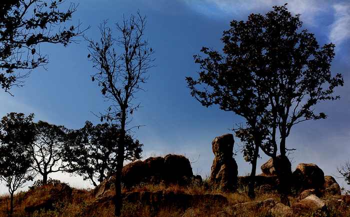
The Magic Rocks of Los Chorros de Tala
|