|
 A
lush jungle and an incredible view A
lush jungle and an incredible view
In the shadow of Tequila Volcano
By John Pint
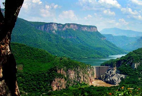
The gargantuan canyons west of Guadalajara, carved by the
Santiago River, shelter lush valleys where semi-tropical
vegetation flourishes all year round. The soil was enriched 65
million years ago by ash fall from nearby Tequila Volcano and on
top of that, countless springs in the area pour forth an
abundance of clean, cool water, even at the height of the dry
season. The Santa Rosa Valley, located 40 kilometers northwest
of Guadalajara, not only produces mangoes and papayas, it’s also
a major source of electricity, thanks to a 61 megawatt dam on
the Santiago River.
Until recently, a visit to this picturesque valley required a
bone-jarring ride over a long cobblestone road connecting
Amatitán to the dam. Recently, however, the road has been
asphalted, suddenly turning isolated Santa Rosa Valley into a
potential tourist attraction.
The tequila manufacturers must have known about the new road far
in advance of everyone else, because they have already built a
splendid mirador (lookout point) above the valley, complete with
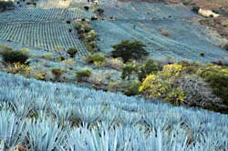
half a dozen giant, bilingual tablets reminding us that the blue
tequila agave originated in this very barranca and describing
the relationship of the valley to the earliest days of tequila
distilling. It seems that the oldest known distilleries in this
part of Mexico were located somewhere between Amatitán and the
mirador, literally carved into a sheer canyon wall to take full
advantage of gravity in the production of tequila. The process
began at the highest elevation where the agave heads were baked
in traditional pit ovens dug into the rock. On a lower level, a
horse-driven mill crushed the cooked agave and the juice flowed
through small channels to 40 fermentation wells carved into the
rock. From there, the fermented juices flowed down to the
distillation area.
After reading all about tequila and soaking up the gorgeous view
from the mirador, you have several choices. One could be to
drive 2.5 kilometers down to the village of Chome, park and take
a stroll along the cobblestone road leading to Balneario La
Mata. You’ll start off surrounded by a sea of blue agaves
stretching off to the distant canyon walls. Then, suddenly you
find yourself engulfed in a matrix of lush green foliage, a kind
of tunnel into a jungle world that is at its very best in the
rainy season. After 1.7 kilometers you arrive at the balneario
where you can take a cool dip in the wonderful spring water that
makes this valley such a paradise.
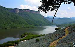
A second choice is to drive 8.7 kilometers down the newly paved
road to a point overlooking the huge lake created by the dam,
some 404 million cubic meters of badly contaminated water. To
reach this spot, keep an eye out for a sign saying Subestación.
This gets you onto a good quality cobblestone road. After only
1.6 kilometers, the road forks. Here you can park and walk
uphill less than 200 meters to what could be called Lakeview
Point. If the Santiago weren’t so horribly polluted, this
beautiful lake could surely be turned into an outstanding
recreational area.
A third choice would be to stick to the paved road from the
mirador and go all the way down (about 10 kilometers) to a
bridge crossing the river. From here it’s an eye-and-ear-popping
drive up a spectacular canyon road leading to the really
isolated town of El Salvador, but that’s another tale for
another day.
How to Get There
Drive west out of town toward Nogales. When you reach the town
of Amatitán, turn right just before the first overhead
footbridge across the highway. This road is now signposted “El
Salvador” and takes you straight to the mirador, nine kilometers
to the north. Driving time from Guadalajara’s Periférico to the
mirador is only about 45 minutes.
|