Update on the Mirador de Santa Rosa/ Santa Rosa Vista
Chapter 11 of Outdoors in Western Mexico, 2011 edition
From:Eileen Collard
DATE Jan 2, 2015
 Our goal today was to try to find the Mirador de Santa Rosa. And I think we did it!
Basically,
we followed the instructions on p. 63 of Book 1 to get to Santa Lucia,
starting out with GPS coordinates for La Mesita of N 20°50.161' W 103°
29.817' as a guide. We were a group of 11, plus our driver, in a large
van heading out from Chapala. It took about 30 minutes to get from
Santa Lucia to what we think was one of the "grassy knolls" you mention
in the book. The GPS coordinates for that "grassy knoll" spot are N
20°51.634' W 103°31.856. The distance between La Mesita and the
"grassy knolls" is about 4 km. of rough driving.
We didn't see
the "little roadside shrine" on the way there, but we did see it on the
way back. It's on the south side of a split in the road (we called it
"a glorieta") past Santa Lucia. Since the westbound lane is on the
north side of the split and there's a sort of plant-filled median strip
between the westbound and eastbound lanes, we didn't see the shrine
until later. But that didn't seem to matter; we just kept going and
came to the other landmarks you describe. Manuel (our driver)
made a mistake on the way there, and we were traveling on the wrong
(left) side of the road. We passed right by the shrine but didn't see
it because we were all focused on the vehicle about to drive right at
us in the same lane...
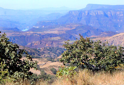
We stopped for lunch, and some of us
walked further on down the road to see what we could see. We climbed a
nearby hill, thinking we could see even more of the panorama, but trees
were in the way. The best view was around the bend in the road, to the
right, about a 5-minute walk from where the van was parked. It was
definitely worth the drive to see it.
We came back a different way.
We turned right onto Carretera a Nextipac in Santa Lucia, which becomes
Hwy 125, drove a short distance, and came to Highway 15. We turned left
on that highway and continued to the Periferico. It was a lot quicker
than taking the Testistan Highway.
I still prefer the views
along the Hwy 23 road to San Cristobal de la Barranca and down to
Huaxtla, but with the highway construction going on there now (they're
making a 4-lane highway), it's not a pleasant drive from the Testistan
Hiway on #23 until you get past the construction.
Incidentally,
the best view of all I've seen is from the Hacienda Lomajim, off of
Hwy. 23. We stayed there one year for our anniversary. Unfortunately,
it's very expensive, the food was not very good, and you can't get into
the property unless you're staying there or are scoping it out for an
event of some sort. The highlight was when we looked down into the
canyon from there and could see a golden eagle flying below us!
So,
that's my travelogue. Thanks so much for your help prior to the trip
and for all the effort you've put into your books. I love having them!
Eileen Collard, Chapala