|
by Peter Ruplinger, Josh Kaggie and Kent Forman
This was our ninth fantastic cave mapping expedition to the
Coahuayana area of Mexico. The Coahuayana valley is on the
border between Colima and Michoacan near the coast.
Now that we’re back, the questions that Kent, Josh, and I are
most often asked are, “Did you find any cool caves?” and “Did
you have any scary experience with drug violence?”
Yes, we explored and mapped nine super caves. We did a lot of
rigorous hiking up steep mountains through dense and beautiful
jungles. We also met a lot of friendly people who were anxious
to help.
No, we didn’t have any scary experiences with drug violence, but
were continually careful where we went and what we did. We
passed two clearly visible marijuana fields and no doubt others,
sheltered from view by dense vegetation. Once we were stopped by
the army, interrogated and searched.
If you are planning a trip to Mexico there are two major points
to remember.
●
Don’t
be out at night.
●
Personally know the people in your immediate area. It is their
“territory”.
The importance of territory can’t be over emphasized. Mexicans
are anxious to help if they know who you are, but if you’re in
the wrong area, and they don’t know you, you may get shot. Don’t
go on other’s property without asking permission. Don’t go into
the back country without a local escort who personally knows the
people where you will be caving.
Similar advice could be offered for Mexican cavers coming to the
United States. Don’t wander or drive into what may be hostile
neighborhoods of major cities, during the day or night.
One of our objectives on this trip was to map El Tapazón, a cave
high on the opposite side of the mountain where we have spent
the past few years mapping the river cave, Cueva de Las Canoas.
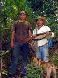
Pedro, who has helped us on prior trips, introduced us to his
neighbor Rafael who knows the Tapazón side of the mountain well.
We ascended thirteen hundred feet over a distance of two and a
half miles through dense jungle to reach El Tapazón. The name
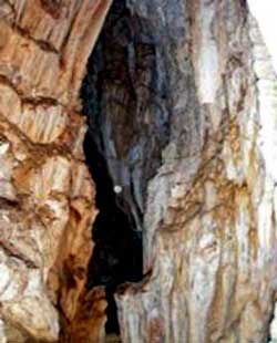
means “the large covering”. The cave’s entrance has a large
overhang which has sheltered locals for millennia.
The cave was somewhat of a disappointment. We heard that it was
large and possibly connected to Cueva de Las Canoas. The cave
only went in about seventy feet. It was, however a beautiful
cave with numerous formations.
Pedro ventured in the cave with us. Rafael had
promised his mother that he wouldn’t go into it. So, he stayed
outside and prepared us a scrumptious barbeque with venison from
a deer that he had shot just the day before.
 His
mother believes caves are inhabited by evil spirits. Perhaps she
is correct. We didn’t see any ghosts, but we did see several
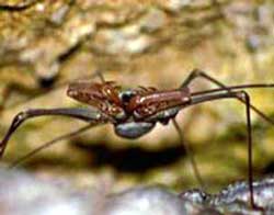
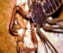
large spider like creatures which the locals call “Tindarapos.”
Cavers know them as “Amblypigids”. They have pinchers and leg
spans sometimes exceeding 22 inches”! They are totally blind.
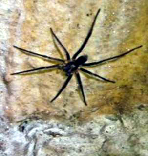
They don’t worry me at all. What do bother me are the tarantula
size, black spiders which we often see in Coahuayana caves. Like
Tindarapos, they are totally blind. Unlike tarantulas, they have
pointed legs and delicate little fangs. They give me the
creeps!. His
mother believes caves are inhabited by evil spirits. Perhaps she
is correct. We didn’t see any ghosts, but we did see several
large spider like creatures which the locals call “Tindarapos.”
Cavers know them as “Amblypigids”. They have pinchers and leg
spans sometimes exceeding 22 inches”! They are totally blind.
They don’t worry me at all. What do bother me are the tarantula
size, black spiders which we often see in Coahuayana caves. Like
Tindarapos, they are totally blind. Unlike tarantulas, they have
pointed legs and delicate little fangs. They give me the
creeps!.
Almost adjacent to El
Tapazón
was a small fissure cave that went in about thirty feet and then
up as a chimney approximately forty feet to the surface.
A stone’s throw to the south was a small tomb-like cave about
four feet in diameter. It went down about ten feet, over ten
feet, and down another twenty feet. Due to its structure, we
named it, “Pierna del Perro”, (Dog Leg).
 On
our descent, we teamed up with Mario, another of Pedro’s
friends. He took us to a hill topped with a mound of sharp
jagged limestone. Snake-like roots wove over the mound like
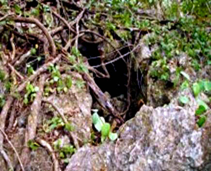
countless guardian serpents. Under the mound was a maze of cave
passages. In the lower area there were numerous shards. Some say
that indigenous peoples would take pots into caves and then, as
part of a ceremony, break them. The cave wasn’t immense, but its
Swiss-cheese-like passages didn’t permit time for mapping. It
has entrances on the east and west sides of the mound. Locals
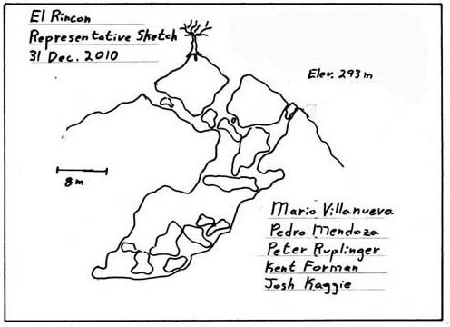
know this cave as, “El Rincón” (The Corner}. I don’t know why. On
our descent, we teamed up with Mario, another of Pedro’s
friends. He took us to a hill topped with a mound of sharp
jagged limestone. Snake-like roots wove over the mound like
countless guardian serpents. Under the mound was a maze of cave
passages. In the lower area there were numerous shards. Some say
that indigenous peoples would take pots into caves and then, as
part of a ceremony, break them. The cave wasn’t immense, but its
Swiss-cheese-like passages didn’t permit time for mapping. It
has entrances on the east and west sides of the mound. Locals
know this cave as, “El Rincón” (The Corner}. I don’t know why.
To the east of El Rincón was a small cave which may have been
used as a tomb. Mario chose to name it “Cueva del Javero.”
Javero is the name of a large tree below the cave.
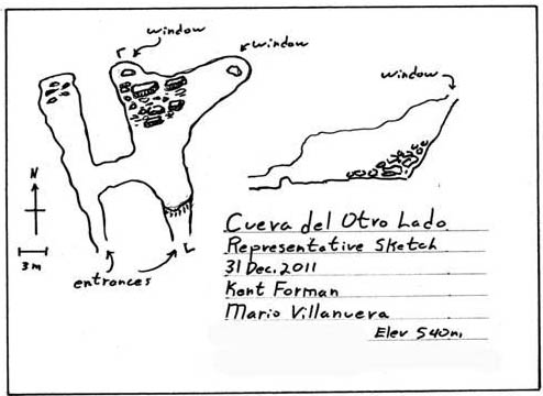
While I was preparing a representative sketch of El Rincón, Kent
and Josh went to the west side of El Rincón and explored our
sixth cave for the day. Mario scratched his head and couldn’t
think of a name for it, so I named it, “Cueva del Otro Lado”
(Cave on the other side).
It was a rough day. In the evening a local family Ricardo and
Maria invited us for dinner. It was a lot of fun. Their two
charming teenaged daughters were enchanted with Josh and dragged
him off to a karaoke party to usher in the new year. Josh came
back a little after twelve boasting that he had sung Moon River.
In the meantime, Kent became a hero by fixing the families’
virus infected computer. I shocked everyone by relating a story
about finding a venomous snake in the cave, and then producing
it from within my shirt. It was rubber of course. Exon, their
eight year old boy roared with laughter and was delighted when I
gave him the snake.
The next day we made a return trip to “Cueva del Rumbo a
Chanchopa” (Cave on the way to Chanchopa). It is located north
of the Coahuayana valley, near the town of San Gabriel,
“Chanchopa” is the name of the town at the base of the mountain
where San Gabriel is nested. “Chancho” is one of several Mexican
words for “pig”. There is a large hog farm in Chanchopa, so
perhaps the town is named after the hog farm. The people there
go out of their way to be cordial, but the area stinks. How
would you like to live in a stinky town called “Pigville”?
During last year’s visit to San Gabriel, Rodney Mulder descended
the pit, but due to the late hour, Kent and I didn’t have time.
On this trip we did. The cave is over four hundred feet deep. It
took nine minutes to descend and twenty-five to climb out. Kent
and I both came face to face, just inches away, with one of
those big black ugly spiders.
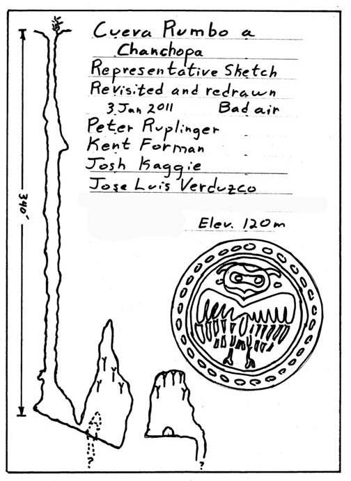
At the bottom the air was bad. A cigarette lighter wouldn’t
begin to light. Kent and I had to breathe twice as fast. I
didn’t venture past the room where we got off rope. Kent went on
to a second, highly decorated room with a hundred foot ceiling.
This second room had a pit at the far end. Due to the bad air,
Kent prudently didn’t drop the cave’s second pit.
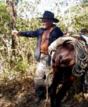
Two days later, back in Palos Marias, one of the town’s oldest
residents, Sirilo, took us to a cave near the summit of the
immense mountain north east of Palos Marias. Sirilo is
eighty-five years old. He has hunted deer and harvested exotic
hardwoods in this area all his life.
 Sirilo
rode his little donkey. The rest of us walked. To save time we
didn’t take the switchbacks, but marched straight up the hill.
It was an arduous hike. Josh fell on sharp, weather eroded
limestone and cut his shin. Kent, who always carries every
possibly needed item in his huge backpack, produced butterfly
sutures, and other first-aid items to dress the wound. Sirilo
rode his little donkey. The rest of us walked. To save time we
didn’t take the switchbacks, but marched straight up the hill.
It was an arduous hike. Josh fell on sharp, weather eroded
limestone and cut his shin. Kent, who always carries every
possibly needed item in his huge backpack, produced butterfly
sutures, and other first-aid items to dress the wound.
The scariest experience of our expedition was when an area where
we sat to rest suddenly began to slide down the hill. The rocks
rumbled like thunder. Fortunately they only slid about five
feet. When the rocks stopped, my left leg was pinned to the knee
between two boulders. Fortunately I was able to remove it. We
carefully crept to safer ground.
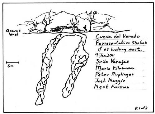
Sirilo says there are numerous caves on the mountain. It’s just
a matter of finding them. He found this cave ages ago when he
shot a deer. He tracked the wounded deer to the entrance of the
cave, where it had fallen. Sirilo wasn’t aware of a name for the
cave. Mario said we should call it “Cueva del Venado” (Cave of
the Deer).
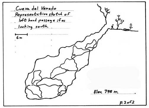
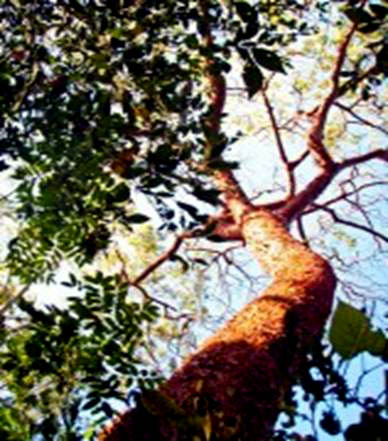 The
cave was in a beautiful area with huge trees. There was only one
opening, but it quickly divided into two parallel fault-like
passages. Once again, we simply did not have time to make a
detailed map. About half way down the right-hand passage, I
found what appeared to be a pedestal. It consisted of four fist
sized stones with a dish-like stone on top of them. It was in a
shrine-like corner area. It was obvious it had been placed there
by hand. Below the pedestal was a large elegant pot, broken to
pieces. The
cave was in a beautiful area with huge trees. There was only one
opening, but it quickly divided into two parallel fault-like
passages. Once again, we simply did not have time to make a
detailed map. About half way down the right-hand passage, I
found what appeared to be a pedestal. It consisted of four fist
sized stones with a dish-like stone on top of them. It was in a
shrine-like corner area. It was obvious it had been placed there
by hand. Below the pedestal was a large elegant pot, broken to
pieces.
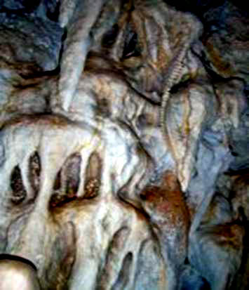
Although moderate in size, the cave was heavily decorated.
Almost every surface was covered with veils, stalactites,
stalagmites, and shark tooth draperies.
Our last cave of the expedition was once again on
top of a humongous mountain. I thought our guide, Ramon, looked
familiar. On the hike, once again straight up the hill, he told
us that cavers had been there before, but had not reached the
cave’s bottom due to its immense depth. Once at the cave, I
realized that this was the same cave I had been to in January of
2000. Ten years ago we ascended on the opposite side via
switchbacks. Mario’s younger cousin, Noe, carried our ropes on
his mule. Mario didn’t recognize me now because of my mustache.
 The
cave has a spectacular entrance. It is near the top of the
mountain, beside a jagged weathered limestone cliff. The entry
room is about thirty feet across. On the side is a pit about two
by four feet wide. Its lip is covered with slimy black guano.
The pit has an overpowering stench of ammonia. When large rocks
are dropped into the pit, disturbed bats swarm with the sound of
surf smashing on a rocky shore. We could never hear the rocks
hit the bottom. The
cave has a spectacular entrance. It is near the top of the
mountain, beside a jagged weathered limestone cliff. The entry
room is about thirty feet across. On the side is a pit about two
by four feet wide. Its lip is covered with slimy black guano.
The pit has an overpowering stench of ammonia. When large rocks
are dropped into the pit, disturbed bats swarm with the sound of
surf smashing on a rocky shore. We could never hear the rocks
hit the bottom.
This is the cave where Lynn Anderson and I contracted
histoplasmosis ten years earlier. Perhaps that was our
recompense for not descending the abyss. We didn’t descend it
this trip either. Perhaps it is the world’s deepest cave. Who
knows?
THE END
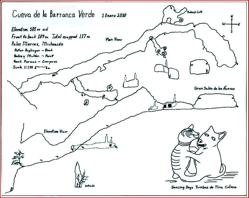
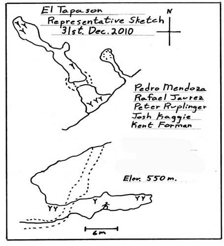
Editor's note: On previous visits to the Palos Marias area,
Peter Ruplinger's team found the two caves whose maps appear
below. Note: the drawings are for decorative purposes only.
There are no artifacts in these caves!
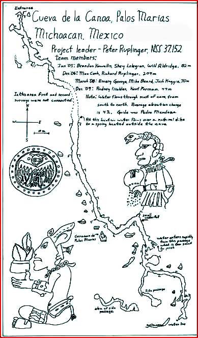
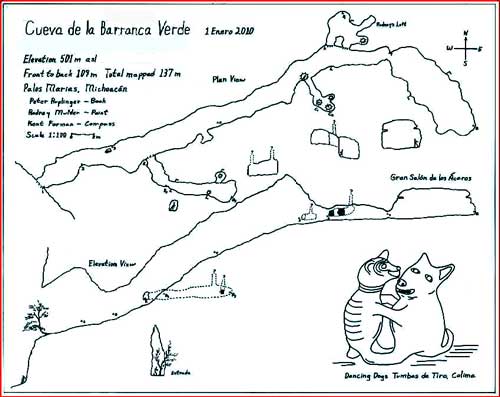
Click on the image to see a larger version of the map. |