|
When Heiko Dirks and I visited Ain
Heeth (Ain Hit, Ain Hith, Ain Heet) February 19th, 2008, we
were able to descend into the lowest room
that had been explored by divers in 2002. At the time the water was
crystal clear and bluish (Fig. 1), thin calcite rafts were swimming on
the surface (Fig. 2) and we could study the dissolution features of the
cave, typical for dissolution of convecting water, i.e. sections of
flat solution ceilings with the typical solution cups (Fig. 3), smooth,
sloping side-walls, so called “Facets” (Fig. 4) and ragged protrusions
(Fig. 5). We even took a water sample (Fig. 6) that was accidentally
half drunk (in spite of clear labeling!) at a party the following
night. Luckily we had not poisoned the sample, as we might have done if
it had been destined for organic geochemistry.
According to the survey Gregg Gregory
and others made in December 2002 we must have been at a depth
146 m below the lip of the entrance, at that time the deepest
point reachable in a cave in Saudi Arabia. The northward
passage, explored by the divers was not yet accessible at that
time.
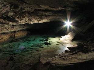
Fig. 1. The lake at the bottom of Ain Heeth in February 2008:
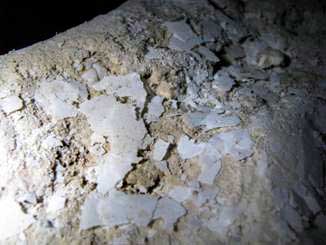
Fig. 2. Calcite rafts at the bottom of Ain Heeth, February 2008
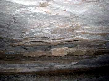
Fig. 3. Solution Ceiling in Ain Heeth
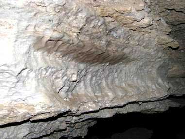
Fig. 4. Sloping sidewalls, typical of density-driven convective
dissolution.
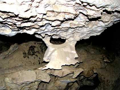
Fig. 5. Ragged protrusions (pendants) typical of hypogenic
convective dissolution.
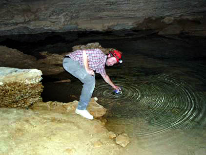
Fig. 6. Water sampling in the clear ground water of Ain Heeth in
2008
We had heard from colleagues of Heiko,
who had made the trip down the cave a few month earlier, that
they did not see our water level mark left in 2008 (Fig. 7) and
they said that they did not enter a relatively low hall at the
end, but that the floor sank steeply below the water level.
Thus we were eager to return, to check
on the water level condition and take another water sample.
Opportunity arose on the afternoon of January 24th, 2011, after
I had given a talk about lava caves and the hydrological
potential of the Harrats at the Ministry of Water and Energy (MOWE)
at Riyadh.
We took some time out to use a new dirt road to drive
around above the escarpment and after following a few blind
leads, finally found the dirt road that leads to the
North-oriented embayment that harbors the entrance to the cave.
This time the dirt track runs through the gravel pit in front of
the embayment and is only passable with a 4WD, such as Heiko’s
Toyota. We parked about 60 m away from the lip of the entrance,
to be clear of any stones that might fall from the crumbling
walls of lower Cretaceous, platy rocks that surround the
embayment.
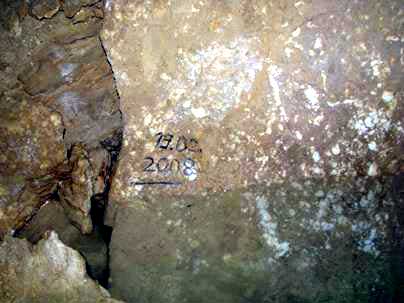
Fig. 7. Water level mark left by us in
February, 2008 at the bottom of Ain Heeth.
At about 4 PM we had helmet, camera
and backpack ready and approached the gaping entrance. From the
lip of the descent one formerly had a magnificent view down the
sloping passage (Fig.8), but now the view is obstructed by a
massive pile of fallen Cretaceous debris (Fig. 9). This collapse
of the western wall above the cave must have happened rather
recently because the stones looked very fresh and had not been
treaded on. Possibly the rain of a few days ago had dislodged
them. While we scrambled in (wisely keeping to the eastern side
of the cave mouth), more stones fell and tumbled down the slope,
just as happened to us on the way out, when stones kept on
coming down.
We
moved, accordingly, quite quickly downward, sometimes sliding together
with rocks, to get away from the vertical wall above us, when we
realized that also the Heeth Anhydrite, the famous Upper Jurassic
aquiclude of Saudi Arabia, had produced rock falls. These rocks are
more like boulders, the smaller a few 100 kg and the larger ones of
truck size. Where formerly a car wreck (however it got down here we
don’t know) (Fig. 10) rested, now big, newly fallen blocks covered it.
If this was one event or if these monstrous spars came down one by one
cannot be said, but their fall had generated ubiquitous dust, that
covered everything, including the garbage that reappeared in the deeper
parts of the descent that were not affected by collapse. As quickly as
possible we descended and came to the rocks where a rope hangs and that
lead to a small passage between blocks behind which is a larger room.
In this part the edges of the anhydrite blocks are quite polished from
people traveling. Many inscriptions “crafted” in industrial paint occur
here. Another climb and turn down brought us to a very steep decline
made of anhydrite slabs and below us, our helmet lights illuminated a
darker plane, the current water level.
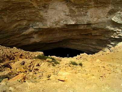
Fig. 8: Opening of the cave in February 2008 (S. Kempe standing
in center; Photo by Dirks).
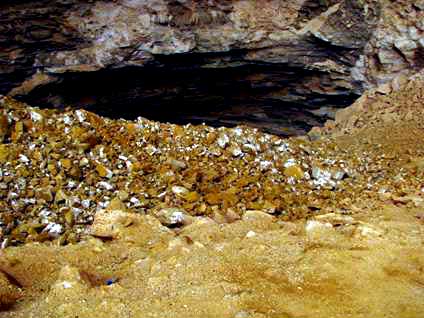
Fig. 9 Ain Heeth entrance partly filled with a new rock
avalanche.
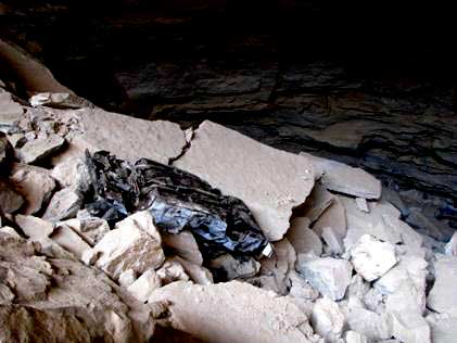
Fig. 10 Formerly visible car wreck on the left side of the
descending Ain Heeth tunnel.
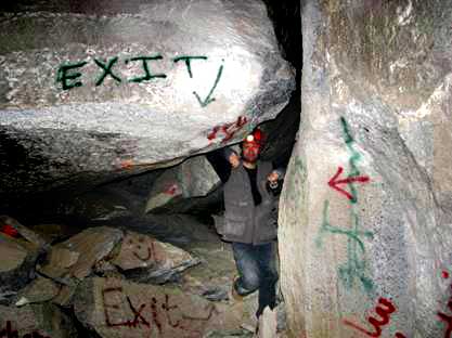
Fig. 11 narrow passage between rocks, marked profusely in case
one should get lost…
A light malodorous smell surrounded us
and when we stood at the water’s edge (Fig. 12), we noticed that
the lake was not only dotted with floating garbage but also was
covered with a grey bacterial slime, producing bubbles (Fig.
13). We were somewhat relieved to have Petzl LED lamps and no
carbide as in the old days, because the gas could easily be
methane. Heiko took – careful to avoid wetting his fingers – a
water sample and we made sure not to step or fall into this
slimy broth.
After taking some pictures of the
room we decided to survey back up to find out exactly where the
water table was now, because for sure it was now higher
(surprisingly) than in 2008 (Fig. 14 and 15). Seventeen stations
and 117.3 m higher we reached the exit at about 7 PM in the
dark. A pair of beady eyes had been watching our slow ascent
from the newly fallen rubble and the voice of the muezzin from
Kharj reverberated in the embayment as if in a large parabolic
reflector.
Comparing our data with that of the
survey of Gregg Gregory and co-workers from 2002, we encountered
the water table ca. 27 m higher than in 2008 at our first visit.
Two days later we heard from the Ministry of Water and Energy (MOWE)
that 7 km to the north, sewage from Riyadh is forming a lake
along the escarpment (see Google Earth). Thus Ain Heeth is
involuntarily providing us with a karst tracer experiment. At
this time it looks like the water table is going to keep on
rising and that trillions of bacteria are making a comfortable
living down there. Considering the filthy condition of the water
and the recent rock falls, the cave has lost its recreational
value, having turned into a very obnoxious and quite dangerous
place. I doubt that I will make that trip again…
Stephan Kempe, Darmstadt, January. 26th,
2011
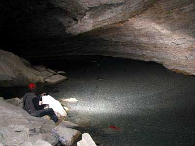
Fig. 12. The water table on February 24th 2011 at Ain
Heeth.
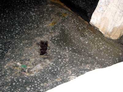
Fig. 13. Bacterial slime and bubbles of gas (methane?).
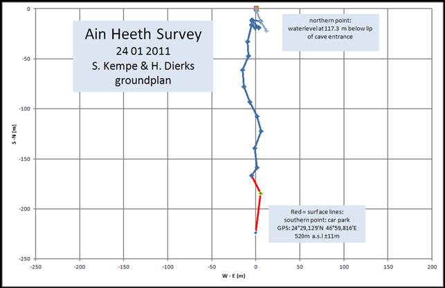
Fig. 14. Ground plan of Ain Heeth
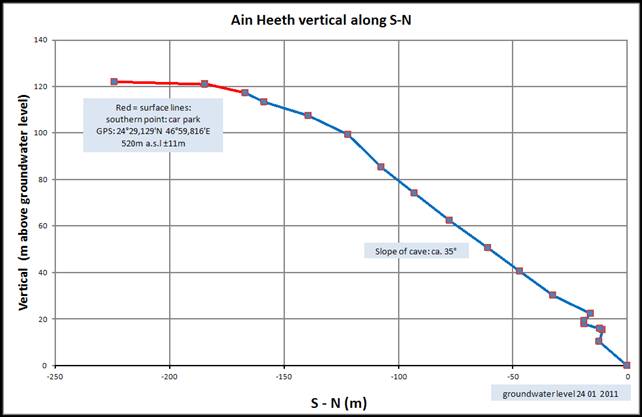
Fig. 15. Vertical section along South (left) – North (right)
projection.
|