|
By John Pint
 In the first volume of Outdoors
in Western Mexico,
I described the Seven Falls of Tonalá, located just east of
Guadalajara, as “one of this city’s best—but least known—natural beauty
spots.” So, I was
quite surprised while recently surfing the net, to discover a snazzy
web page proclaiming the innumerable attractions of “Parque
Ecoturistico Las 7 Cascadas.” There were flashy pictures of smiling
kids zooming down ziplines, scrambling across hanging bridges and
rappelling into enticing natural swimming pools—along with mention of a
heavy entrance fee to what looked like Jalisco’s answer to Disneyland.
In the first volume of Outdoors
in Western Mexico,
I described the Seven Falls of Tonalá, located just east of
Guadalajara, as “one of this city’s best—but least known—natural beauty
spots.” So, I was
quite surprised while recently surfing the net, to discover a snazzy
web page proclaiming the innumerable attractions of “Parque
Ecoturistico Las 7 Cascadas.” There were flashy pictures of smiling
kids zooming down ziplines, scrambling across hanging bridges and
rappelling into enticing natural swimming pools—along with mention of a
heavy entrance fee to what looked like Jalisco’s answer to Disneyland.
“I guess it’s time for me to revisit 7 Falls,” I told myself.
Recalling
that the major problem associated with this particular place had always
been the bad road leading to it, I scrutinized this web page for
precise directions…but found none. So, I turned to Google Maps which
immediately recognized the site and gave me a route—a very curious
route indeed—to get there.
A few days later, Josh Wolf and
I—together with his whole family followed that Google route, which sent
us along Calzada Lázaro Cardenas to the newly constructed Periférico
Oriente (Eastern Ring Road). Well, these are two major highways and
you’d imagine they would be connected, right?
Wrong, as far as I
can see, but why, I can’t guess. No problem, however, because Google
Maps, heh, heh, managed to find a way for us to get on to the
Periférico Oriente via a small, obscure tunnel under Lázaro Cárdenas.
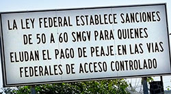
Just before the tunnel, however, we were greeted by a huge sign
informing us that the Federal government imposes big fines on people
who try to avoid paying tolls on Federal highways.
Well, we
sat in the car for a while debating what might happen to us if we went
through the tunnel. We had seen no toll booths anywhere in the vecinity
and—seeing no police around to whom we could make inquiries—we took the
plunge, passed through the tunnel, and in a minute found ourselves
heading north on the new Eastern Periférico.
All of this proved
merely the beginning of our saga. Google Maps next told us to exit the
Eastern Periférico onto what can only be described as The Camino from
Hell. It would be fun to do in a Jeep, but how Josh’s car ever survived
it, I don’t know. Unless you have 4WD, don’t follow this ill-starred
route. Use the easy route mentioned below.
Inching our way
up the bad road, we eventually came to a ramshackle building (with no
sign) from which emerged a wiry fellow with a genuine ranchero suntan.
“We’re looking for las 7 Cascadas,” said Josh.
“”You’ve found them!” replied the man. “Twenty pesos per person,
please, and the kids are free!”
“This is the Parque de Deportes Extremos, verdad?” I asked.
“Oh no, we don’t have those activities anymore. There’s just the
walking trail from one fall to the next.” 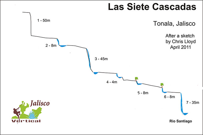
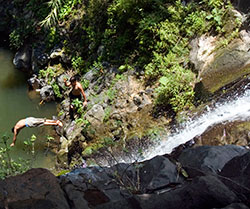
Las Siete Cascadas de Tonalá. After a map of the Seven Falls by Chris Lloyd
While
we visited the first fall, which is 50 meters high, the caretaker told
us that at least two people had been killed here doing extreme sports
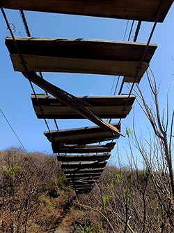
like rappelling and ziplining, causing the place to be shut down. A
glance at the shoddy remains of a hanging bridge gave us an idea of
what sort of safety standards must have prevailed during the Adventure
Park’s brief existence.
Next we took a look at a shaded picnic
platform with a magnificent view of the canyon below us. “We allow
camping too,” said the ticket collector, “and if you stay overnight
here, you just might spot El Jinete Sin Cabeza, The Headless Horseman.
I’ve seen him often.”
In Outdoors in Western
Mexico, I mention
that the steep path to falls 2 to 7 “is not exactly the kind you would
find in Central Park, and some grunting and groaning may be needed to
help you up or down the trickier spots.”
Well, now, at age 75, I
would give this trail a much higher grunt-and-groan rate, so, even
though the distance from the entrance to Fall Number Two is only 534
meters, think of this as an obstacle course designed to test your
mettle. Just take your time and move along slowly, bearing in mind that
(believe it or not), it’s much, much easier coming back up.
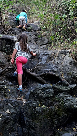
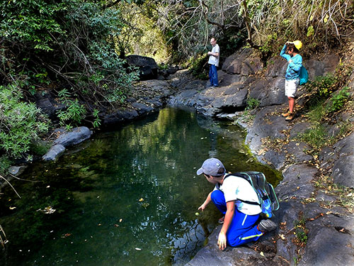
At
last we reached Fall Two, disappointed to find that the “river” is now
just a trickle. This has allowed the pool at the foot of the fall to
fill with leaves and other debris, discouraging swimming, even though
the water comes from a spring and is not polluted. 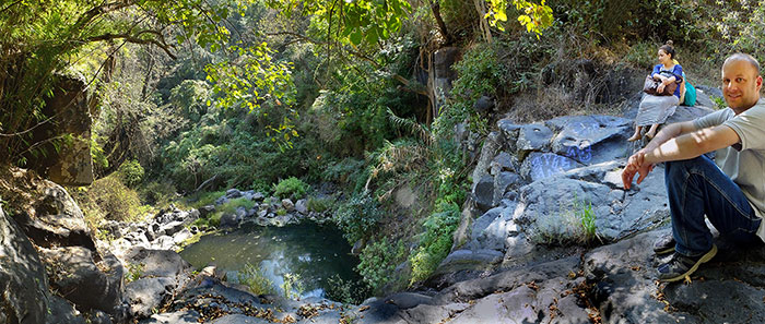
Rayo and Josh Wolf at what remains of Waterfall Number Two of the Seven Falls.
Back up at
the top, I asked the caretaker if there was any alternative to the
Camino from Hell for getting back to the Periférico. To our relief, he
told us about an easy route, suitable for any sort of vehicle. Since
the Periférico Oriente starts from the Chapala highway (just north of
the airport), it means that lakeside dwellers can get to the 7 Falls
far more easily than people in Guadalajara, who still have to take
their chances with the possibly illegal tunnel under Lázaro Cárdenas.
All in all, if you are looking for adventure, 7 Falls is still the
place to go!
How
to get there
From Chapala:
About 300 meters
north of the airport exit, turn right onto the Nuevo Periférico Oriente
and follow it 18.7 kilometers to an unmarked exit at N20 38.084 W103
12.587, just after an overhead pedestrian bridge. From here it is only
a two-kilometer drive—on a decent road— to 7 Falls Entrance (N20 38.561
W103 11.837) and you can see the route on Wikiloc.com under “Seven
Falls Driving Route.”
From
Guadalajara: Take Lázaro Cárdenas
east to a point (N20 37.166 W103 12.562), 500 meters after you pass
over the Nuevo Periférico Oriente. Creep along slowly here. You will
see an exit reading “Desarroyo Habitacional / Centro de Distribución.”
Don’t take this, but continue on the main road a few more meters. Now
you will see a narrow lane on your right. Ease off the highway and—at
your own risk—take this lane down to a tunnel under the highway. Turn
left to go through the tunnel and left again to get to the Periferico
heading north. Go north 1.7 kilometers, pass under the overhead
pedestrian bridge and immediately take the unmarked exit mentioned
above in the directions from Chapala. Again, you will find the route on
Wikiloc.com under “Seven
Falls Driving Route.”
|